"Smart Low Altitude" Integrated Government Services

Business Needs

■ Redundant equipment procurement and resource waste
■ High barriers to data processing
■ Lack of a unified management platform
■ Severe data siloing
■ Shortage of professional UAV flyers
■ Prominent problems of "fear of flying"
■ Complex application process resulting in unauthorized flights

Our Advantages

  • Full-ScenarioCoverage&Unified Dispatch Management

    Thesystem leverages distributed docks and 5G networks to build a low-altitude sensing network,which enablesend-to-endprocess automation ofUAV operation and unified dispatch of multi-department tasks.

  • Intelligent Coordination &Efficient Response:

    By integrating AI and other technologies, UAVsare capable of automated operation, intelligent identification, and rapid response via a 3D base, enhancing urban governance efficiency.

  • Data Fusion BreakingDown Information Silos:

    A unified platform that consolidates multi-department data builds a low-altitude Internet of Things sensing system, providing multi-dimensional data for urban governance and facilitating scientific decision-making.

  • Modular Deployment forFlexible Adaptation:

    The system supports on-demand deployment of payloads and service modules and provide customized solutions for environmental protection, inspection, disaster relief, prevention and control, etc., thereby lowering the barrier to entry for users.

  • Standardized, SafeFlight with Regulatory Compliance:

    By adopting a standardized flight system with automated airspaceapplication, the solution resolves the “fear of flying” issue, eliminating unauthorized flights and ensuring safety.

  • Strong Scalability forRegional Models Building:

    The system supports technological iteration and scenario expansion, providing a reusable application paradigm for smart cities and low-altitude economy, and promoting the industry and city integration and the development of regional low-altitude industrial ecosystems.

Solutions

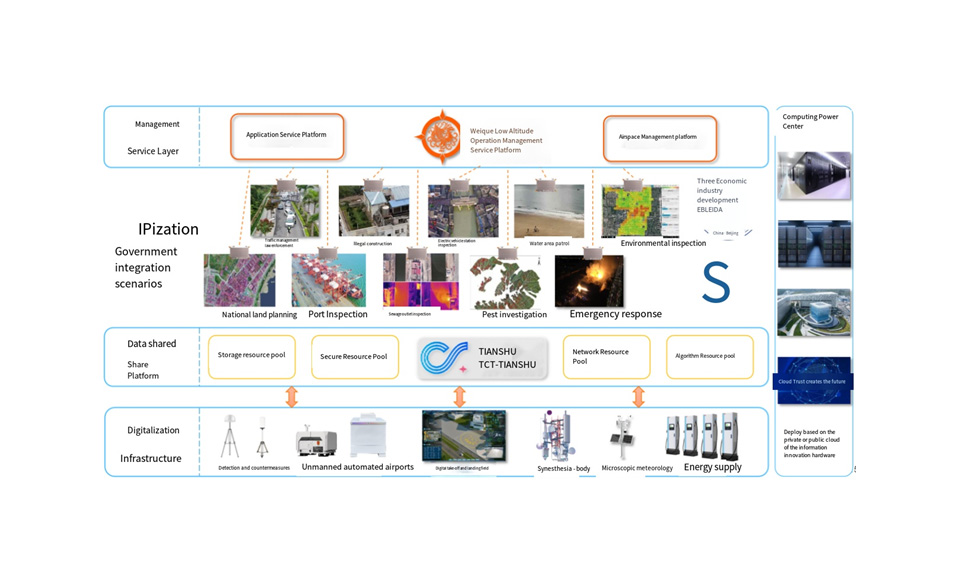
■ Based on distributed docks and advanced technologies, the solution builds an air-ground coordinated low-altitude sensing network and creates a government low-altitude UAV service system.
■ The solution establishes an integrated low-altitude application system that providessensing data for the regional digital base,driving the industry and city integration and governance transformation.
■ The deployment of a 3D grid base enables autonomous operations and AI processing, which facilitates early detection and resolution of problems withfull data visualization.
■ The deployment of modular service functions provides targeted comprehensive solutions for multiple departments.

System Components

Cloud platform, DJI Dock 3, Strawberry M350 Dock, Mobile operating unit system, VTOL fixed-wing UAV, tethered UAV, firefighting UAV, loudspeaker, payload dropper, searchlight, full-frame mapping camera, airborne LiDAR, airborne radar flow velocity meter, gas detector, airborne multi-parameter water quality meter, multispectral camera (model, payload, endurance, mount), etc.

Functionality

■ Cost Reduction &Efficiency Gain: In comprehensive urban governance, emergency disaster response time is reduced to within 10 minutes; inspection workload decreases byover 30%; costs lower by over 30%; and efficiency improves 4-6 times.
■ Asset Reactivation: Existing UAVs by government departments are reused via cloud boxes to reduce asset investment and reactivate government fixed assets.
■ Industry Stimulation:The construction and operation of the project foster the entire UAVindustrial chain, including manufacturing, data services, industry applications, etc., creating an industrial multiplier effect.