"Water Guardian" (Including Wetlands) Low-Altitude Intelligent Inspection Solution

Business Needs

■ Low efficiency in routine river and lake inspections
■ Difficulty in conducting pre-flood inspections of "Four Disorders (disorderly occupation, mining, construction, anddumping)"
■ Passive Supervision of illegal sand mining
■ Insufficient flood emergency response capacities
■ Numerous blind spots in personnel management across water-adjacent areas

Our strengths

  • All-Domain Autonomous Intelligent Inspection System

    By integrating "UAV + automated dock" technology, an unmanned intelligent inspection system is built to achieve high-frequency autonomous water body patrol, revolutionizing traditional models and enhancing efficiency.

  • AI-Powered Accurate Identification and Automatic Early Warning

    With the aid of computer vision and deep learning algorithms for intelligent analysis of patrol data and accurate identification of targets, the system enables early warnings within seconds, providing intelligent support for governance response.

  • Closed-Loop Intelligent Management Platform:

    A digital cloud platform that consolidates multi-source data enables digitalized closed-loop management of the entire inspection process, replacing paper ledgers and improving management and collaboration efficiency.

  • Air-Ground Coordinated Three-Dimensional Operation:

    The solution innovatively applies a model of "fixed dock + mobile platform + diverse payloads" that forms a three-dimensional water conservancy supervision and emergency response system to ensure high-frequency inspection and precise operation.

  • Scale Validation & Reliable Operation:

    The solution is based on real-world scenarios and is proven stable and practical through flight validations, recognized by water authorities. It efficiently replaces manual labor and meets the requirements of intelligent water management.

Solutions

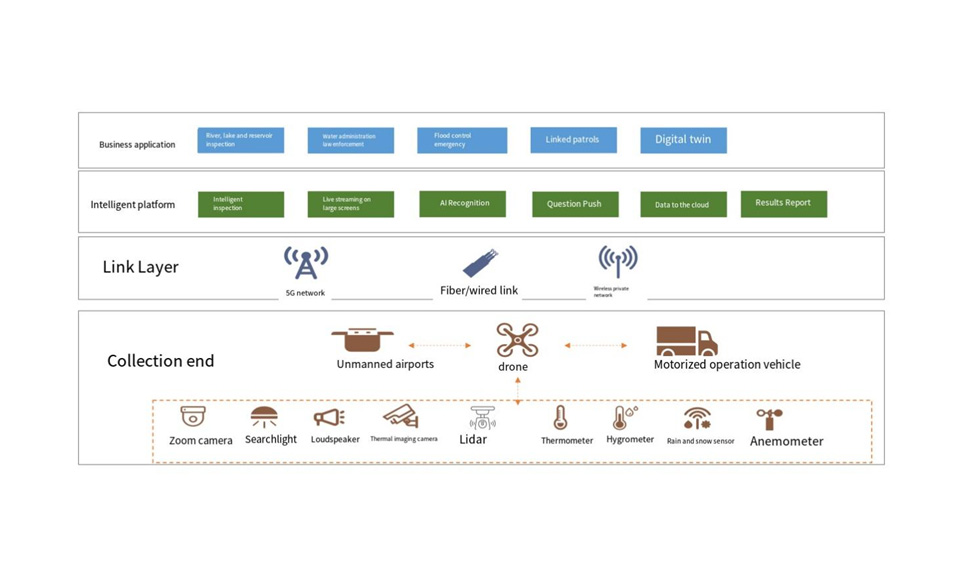
We provide intelligent UAV solutions for the core requirements of water resources management (e.g., river/lake inspection, flood safety, etc.) in low-altitude scenarios. Fixed, high-frequency areas are deployed by integrated systems for automated operation; and specific or low-frequency tasks are served on demand with DJI M400+ payloads.

System Components

■ Core Hardware: Zhuque Intelligent Patrol Cloud Platform, responsible for task management and dispatching.
■ UAVs: DJI M4TD (for high-frequency patrols) and DJI M400 (for special missions).
■ Diverse Payloads: Configurable as needed, e.g.,loudspeakers, LiDAR, etc.
■ Single UAV flight endurance of 45-60 minutes, covering an inspection radius of approximately 5 km.

Functionality

■ Remote communication and warning
■ Nighttime supervision of illegal sand mining
■ High-precision topographic mapping and analysis
■ Water sampling at specified depths
■ Large-area water quality remote sensing
■ Flight safety assurance
■ Precision airdrop of emergency supplies


Application Examples

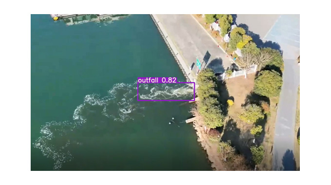
■ Tianjin QilihaiUAV Inspection Project: Pioneering the "low-altitude + wetland inspection" model for wetland ecological protection, the "UAV +AI identification" technical solution provides a replicable benchmark case for the digital transformation of nature protected areas.
■ Xin'an River, Jiande, Water Body Unmanned Inspection Project: The solution explores an integrated air-ground coordinated application model of "UAV + Unmanned Surface Vessel (USV)". Through data interconnection with the Zhejiang Flight Service Center, it achieves integrated airspace operation for both unmanned and manned flights over the Xin'an River.